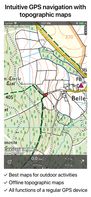
Map Services Page 12 of 13

All apps in Map Services category. Use the filters below to narrow down your search. 

Popular filters:

Copy a direct link to this comment to your clipboard
  1. Tarmacs icon
     Like

    Tarmacs is the route planner app dedicated for road and gravel bikers. It suggests best tarmac and gravel roads thanks to synergy of social sharing. Currently covers Europe.

    Tarmacs: Route planning, with POIs and climb markers
    7 alternatives
  2. Superlocal is the AI Travel Map & Tracker that finds the best places for you — then auto-logs every visit so you can relive the journey. Think Google Maps + Foursquare + Swarm + Fog of World, super-charged by personalization.

    • FreemiumProprietary
    • iPhone
    • Online
    Superlocal screenshot 1
    Superlocal screenshot 2
    Superlocal screenshot 3
    10 alternatives
  3. MapPrints icon
     Like

    MapPrints allows anyone of any skill to design their own amazing art and home decor based on maps of their favorite places. Pick any place on earth. Design your own stunning home decor.

    MapPrints screenshot 1
    8 alternatives
  4. Tasmap icon
     Like

    Tasmap is a clean interface to create your own maps. Design your own color scheme, add content, and combine them into a beautiful map app.

    Tasmap screenshot 1
    1 alternatives
  5. Mapilio icon
     Like

    Access street-level imagery and map data from all over the world. Fill in the gaps by requesting new coverage or capturing your own!

    • Map Service
    • FreeProprietary
    • Online
    • iPhone
    • iPad
    • Android
    • Android Tablet
    • Windows
    • Mac
    • Linux
    • Python
    Mapilio screenshot 1
    Mapilio screenshot 2
    Mapilio screenshot 3
    5 alternatives
  6. bikerouter.de is a web-based route planner for all kinds of bicycles (trekking, road bike, gravel bike, mountainbike, and many more) with specialized and adjustable routing profiles.

    bikerouter.de screenshot 1
    1 alternatives
  7. 1940s NYC icon
     Like

    Between 1939 and 1941, the Works Progress Administration collaborated with the New York City Tax Department to collect photographs of most buildings in the five boroughs of New York City. In 2018, the NYC Municipal Archives completed the digitization and tagging of these photos.

    1940s NYC screenshot 1
    3 alternatives
  8. Find articles from wikipedia/wikivoyage near given geographic location to be displayed in an interactive map through a generated kmz file - GitHub - k3b/AndroidGeo2ArticlesMap: Find articles from wikipedia/wikivoyage near given geographic location to be displayed in an...

    • FreeOpen Source
    • Android
    • Android Tablet
    8 alternatives
  9. Outmap icon
     Like

    Explore the backcountry with the ultimate mountain toolkit. Outmap combines detailed 3D maps, offline access, intuitive library management, and advanced safety tools.

    The Ultimate Mountain Toolkit
    See the Terrain in 3D
    Track and Measure Every Step
    1 alternatives
  10. Modern Map Art takes your favorite cities, mountains, and places and turns them into beautiful works of art. Use the custom editor to create topo maps, street maps, and building maps if your favorite place.

    Modern Map Art screenshot 1
    8 alternatives
  11. Umkreisel icon
     Like

    Customize your own map like never before: Combine background maps with real-time layers like gas prices, weather, traffic, light pollution, and 100+ location filters. Plan trips, find essentials, and explore smarter—all in one app.

    Umkreisel screenshot 1
    Umkreisel screenshot 2
    Umkreisel screenshot 3
    6 alternatives
  12. TrueSize.net is a free interactive map tool that lets you compare the actual land area of countries, states and historical territories — correcting for map-projection distortions and enabling side-by-side size comparisons.

    Welcome screen
    1 alternatives
  13. Hoodmaps icon
     Like

    Hoodmaps is a crowdsourced map to divide cities up into hipsters, tourists, rich, normies, suits, and university areas. Maps of city neighborhood by millions of people around the world. Avoid the tourist traps and navigate cities' hip and alternative areas.

    Hoodmaps screenshot 1
    1 alternatives
  14. The Openstreetmap Contributor app allows anyone to contribute to OSM. It enables those-who-know to easily manage a group of newbies as the contribution process is intuitive and easy. Bring your MapParties to a whole new level!.

    13 alternatives
  15. Anyplace icon
     Like

    Anyplace is a first-of-a-kind GPS-less localization and navigation service working in indoor and outdoor space using ordinary smartphones. It has been developed by researchers and students at the Data Management Systems Laboratory (DMSL), Department of Computer Science and the...

    • Discontinued
    • Map Service
    • FreeOpen Source
    • Online
    • Android
    • Windows Phone
    Anyplace screenshot 1
    9 alternatives
  16. Topo GPS icon
     Like

    Topo GPS is an app that turns your smartphone in a full feature GPS device with topographic maps that are offline available. In Topo GPS you can easily create waypoints, enter, scan, and view coordinates, measure distances and angles, and record, plan and generate routes and...

    Topo GPS screenshot 1
    Topo GPS screenshot 2
    Topo GPS screenshot 3
    6 alternatives