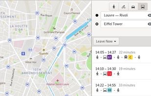
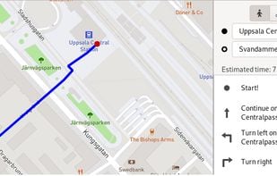
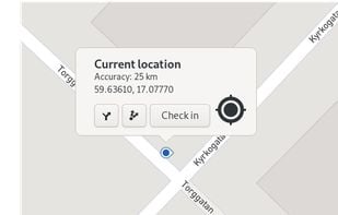
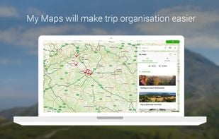
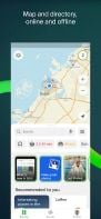
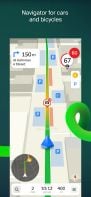
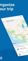
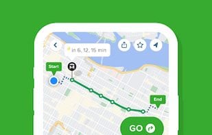
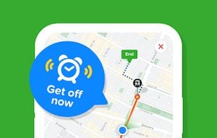
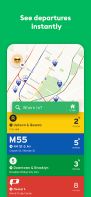
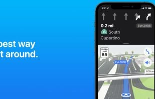
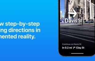
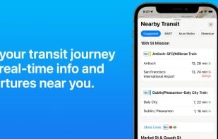
Travel & Location Page 2 of 84

All apps in Travel & Location category. Use the filters below to narrow down your search. 

Popular filters:

Copy a direct link to this comment to your clipboard
  1. GNOME Maps icon
     23 likes

    Maps gives you quick access to maps all across the world. We use the collaborative OpenStreetMap database, enabling our users to make smaller changes to places and points-of-interests.

    Cost / License

    • Free
    • Open Source

    Platforms

    • Linux
    • Linux Mobile
    • Flathub
    • GNOME
    Public transit
    Routing
    Current location
    +1
    Minimalist GUI
    34 alternatives
  2. Cityphoria icon
     5 likes

    Cityphoria is a crowdsourced city review platform that helps people explore, compare, and understand cities based on real user experiences. It lets you discover insights on walkability, safety, affordability, charm, and more — all rated by people who’ve actually lived there.

    Cost / License

    • Free
    • Proprietary

    Application type

    Platforms

    • Online
    Cityphoria screenshot 1
    Cityphoria screenshot 1
    Cityphoria screenshot 2
    4 alternatives
  3. Mapy.com icon
     22 likes

    Global offline tourist maps feature hiking and bike trails, route planning, synced trip organization, panoramic images, public transit info, and local amenities.

    Cost / License

    • Free
    • Proprietary

    Platforms

    • Windows
    • Online
    • Android
    • iPhone
    • Android Tablet
    • iPad
    • Android Auto
    • Apple Watch
    • Apple Car Play
    • Android Wear
    Mapy.com screenshot 1
    Mapy.com screenshot 1
    Mapy.com screenshot 2
    +4
    Mapy.com screenshot 3
    44 alternatives
  4. Leaflet icon
     58 likes

    Leaflet is a modern open-source JavaScript library for mobile-friendly interactive maps. It is developed by Vladimir Agafonkin with a team of dedicated contributors. Weighing just about 28 KB of JS code, it has all the features most developers ever need for online maps.

    Cost / License

    Application type

    Platforms

    • Self-Hosted
    • JavaScript
    Leaflet with clustering
    Leaflet screenshot 1
    Leaflet screenshot 2
    54 alternatives
  5. Panoramax icon
     10 likes

    Panoramax is a digital resource for sharing and exploiting field photos. Anyone can take photographs of places visible from the public highway and contribute them to the Panoramax database. This data is then freely accessible and reusable by all.

    Cost / License

    • Free
    • Open Source (MIT)

    Platforms

    • Linux
    • Online
    • Self-Hosted
    Main web application allowing to see the pictures on the map
    Panoramax screenshot 1
    4 alternatives
  6. 2GIS icon
     72 likes

    2GIS provides 3D-maps of 180+ cities, contacts of 1.5 million companies, car routing and public transport routes and and more! 2GIS is a complete and up-to-date directory of organizations with detailed cities’ maps.

    Cost / License

    • Free
    • Proprietary

    Platforms

    • Online
    • Android
    • iPhone
    • Android Tablet
    • iPad
    • Android Wear
    2GIS screenshot 1
    2GIS screenshot 2
    2GIS screenshot 3
    63 alternatives
  7. uMap icon
     34 likes

    uMap let you create maps with OpenStreetMap layers in a minute and embed them in your site. Add custom annotations, lines, shapes, import and add custom layers (KML, CSV, GPS, ...) and other data.

    Cost / License

    • Free
    • Open Source

    Application type

    Platforms

    • Self-Hosted
    • OpenStreetMap
    • Python
    • Django
    • Leaflet
    • Online
    uMap screenshot 1
    advanced editing features and right-click menu
    55 alternatives
  8. SCEE icon
     5 likes

    Modified for advanced OSM users, SCEE enhances StreetComplete by adding under-tested editing capabilities. Not for those dismissing warning alerts.

    Cost / License

    Platforms

    • Android
    • F-Droid
    SCEE screenshot 1
    SCEE screenshot 2
    SCEE screenshot 3
    9 alternatives
  9. Vespucci icon
     9 likes

    Vespucci is the first OpenStreetMap editor for Android. That means: It is a light-weight, easy-to-use mapping tool on mobile Android devices.

    Cost / License

    • Free
    • Open Source

    Application type

    Platforms

    • Android
    • Android Tablet
    Vespucci screenshot 1
    Vespucci screenshot 1
    Vespucci screenshot 2
    +7
    Vespucci screenshot 3
    17 alternatives
  10. TripIt icon
     49 likes

    TripIt organizes your travel plans in one place. Simply forward confirmations to plans@tripit.com and we’ll do the rest. Access all your flights, hotels, car rentals, activities, maps and more on your WP7. Upgrade to TripIt Pro for peace of mind from check-in to baggage claim.

    Cost / License

    • Freemium
    • Proprietary

    Application type

    Platforms

    • Online
    • Android
    • iPhone
    • Android Tablet
    • iPad
    • Kindle Fire
    TripIt screenshot 1
    TripIt screenshot 2
    TripIt screenshot 3
    82 alternatives
  11. MapComplete icon
     7 likes

    MapComplete is an OpenStreetMap-viewer and editor, which shows you information about features of a specific theme and allows to update it.

    Cost / License

    Application type

    Platforms

    • Online
    • Android
    • F-Droid
    MapComplete screenshot 1
    MapComplete screenshot 1
    MapComplete screenshot 2
    18 alternatives
  12. Booking.com icon
     17 likes

    Online platform offering over 225,000 global accommodations with features like sorting, filtering, and secure, simple 2-step booking process.

    Cost / License

    • Free
    • Proprietary

    Application type

    Platforms

    • Online
    • Android
    • iPhone
    • Android Tablet
    • HUAWEI AppGallery
    • iPad
    Booking.com screenshot 1
    Booking.com screenshot 2
    Booking.com screenshot 3
    50 alternatives
  13. Uber icon
     56 likes

    Uber is Everyone's Private Driver. Use the Uber app to request a private car in any city the service is available. The app lets your driver know precisely where to pick you up, and lets you know exactly how long until they arrive.

    Cost / License

    • Free
    • Proprietary

    Application type

    Platforms

    • Windows
    • Online
    • Android
    • iPhone
    • Android Tablet
    • iPad
    • Apple Watch
    • Android Wear
    • Slack
    Uber screenshot 1
    Uber screenshot 2
    Uber screenshot 3
    61 alternatives
  14. Citymapper icon
     32 likes

    Real-time departures. Transit maps. Line status and real-time disruption alerts. Uber integration. Bike routing and live bike share info. Constant updates. Everything you need -- and may not even realize you need -- to manage your life in the city.

    Cost / License

    • Free
    • Proprietary

    Platforms

    • Online
    • Android
    • iPhone
    • Android Tablet
    • Apple Watch
    • Android Wear
    • Apple Messages
    Citymapper screenshot 1
    Citymapper screenshot 1
    Citymapper screenshot 2
    +5
    Citymapper screenshot 3
    53 alternatives
  15. KDE Itinerary icon
     7 likes

    KDE Itinerary is a digital travel assistant with a priority on protecting your privacy.

    Cost / License

    • Free
    • Open Source

    Application type

    Platforms

    • Linux
    • Android
    • KDE Plasma
    • Snapcraft
    • Linux Mobile
    • Flathub
    • F-Droid
    • Plasma Mobile
    • Haiku
    KDE Itinerary screenshot 1
    KDE Itinerary screenshot 2
    KDE Itinerary screenshot 3
    85 alternatives
  16. Kartaview icon
     18 likes

    KartaView is a free and open platform for street level imagery. Anyone can contribute images with a smartphone and the open source apps.

    Cost / License

    • Free
    • Proprietary

    Platforms

    • Online
    • Android
    • iPhone
    • OpenStreetMap
    • JavaScript
    • Leaflet
    Kartaview screenshot 1
    Kartaview screenshot 1
    Kartaview screenshot 2
    +1
    Kartaview screenshot 3
    9 alternatives
  17. Every Door icon
     6 likes

    Mobile editing tool for OpenStreetMap adds shops, amenities, and POI. Supports offline use, micro-mapping, and user-contributed map updates.

    Cost / License

    Platforms

    • Android
    • iPhone
    • HUAWEI AppGallery
    • iPad
    • F-Droid
    Every Door screenshot 1
    Every Door screenshot 2
    Every Door screenshot 3
    10 alternatives
  18. iD icon
     12 likes

    iD is an OpenStreetMap editor programmed in JavaScript with the aims to be simple and friendly.

    Cost / License

    • Free
    • Open Source

    Application type

    Platforms

    • Online
    15 alternatives
  19. KAYAK icon
     32 likes

    Compares hundreds of travel sites for flights, hotels, and car rentals, provides direct booking access, itinerary management tools, and price alerts.

    Cost / License

    • Freemium
    • Proprietary

    Platforms

    • Online
    • Android
    • iPhone
    • Android Tablet
    • iPad
    KAYAK screenshot 1
    KAYAK screenshot 2
    KAYAK screenshot 3
    94 alternatives