All Travel & Location Apps Page 8 of 103

All apps in All Travel & Location Apps category. Use the filters below to narrow down your search. 

Popular filters:

Copy a direct link to this comment to your clipboard
  1. The True Size icon
     4 likes

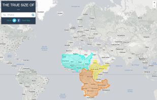
    It is hard to represent our spherical world on flat piece of paper. Cartographers use something called a "projection" to morph the globe into 2D map. The most popular of these is the Mercator projection.
    Cost / License

    • Free
    • Proprietary

    Application type

    Since

    • Since 2016

    Platforms

    • Online
    The True Size screenshot 1
    4 alternatives
  2. PeakNav icon
     1 like

    PeakNav drapes satellite imagery, OpenStreetMap trails and place names over a real elevation model of the whole planet. Fly over any range, tap a summit to orbit it, point your phone at the horizon to name the peaks in front of you, or open a photo and have it tagged with the...

    Cost / License

    Since

    • New

    Platforms

    • Windows
    • Mac
    • Linux
    • Android
    • iPhone
    • iPad
    • Android Tablet
    The Matterhorn in 3D above the Zermatt ski runs and lifts, with the peaks named
    A photo matched by its skyline, with the summits named (Zermatt)
    Tap a summit: fly there, orbit it or route to it
    +3
    Fly along a GPX track with its height profile (Tour du Mont Blanc)
    9 alternatives
  3. iToolab AnyGo icon
     4 likes

    Spoof GPS location on iOS and Android, simulate routes with custom speed, and use in AR games or any app. Compatible with latest versions and computers.

    Cost / License

    • Freemium
    • Proprietary

    Since

    • Since 2020

    Platforms

    • Windows
    • Mac
    • Android
    • CN flagChina
    iToolab AnyGo screenshot 1
    iToolab AnyGo screenshot 1
    iToolab AnyGo screenshot 2
    +3
    iToolab AnyGo screenshot 3
    11 alternatives
  4. Map Chart icon
     1 like

    Create your own free custom Map of World, Europe, Asia, United States and others in 3 easy steps. Download it for free and use it for a great visual representation.

    Cost / License

    • Freemium
    • Proprietary

    Application type

    Since

    • Since 2016

    Platforms

    • Online
    Map Chart screenshot 1
    20 alternatives
  5. QMapShack icon
     7 likes

    QMapShack is the next generation of the famous QLandkarte GT application, the GIS app to display your GPS data on a variety of maps.

    Cost / License

    Since

    • Since 2016

    Platforms

    • Windows
    • Mac
    • Linux
    • Bitbucket
    QMapShack screenshot 1
    23 alternatives
  6. Arrow is a lightweight navigation app designed for travellers who want to explore without distractions. Instead of a map, you get a clean arrow that always points you in the right direction - no zooming, dragging, or rerouting needed.

    Cost / License

    • Free
    • Proprietary

    Application type

    Since

    • Since 2025

    Platforms

    • Android
    Arrow: Offline GPS Navigator screenshot 1
    Arrow: Offline GPS Navigator screenshot 2
    Arrow: Offline GPS Navigator screenshot 3
    42 alternatives
  7. BustimeFinder is a free web app for exploring bus routes, stops, timetables, live maps, operators and vehicle records. It can be used without creating an account.

    Cost / License

    • Free
    • Proprietary

    Application type

    Since

    • New

    Platforms

    • Online
    Search bus routes, places, stops and vehicles without signing up.
    Compare planned times with journey observations. Approximate passages are marked ≈.
    Recorded London and Dublin live-map examples. Coverage and detail vary.
    +1
    Vehicle profiles and published UK livery colours where available.
    2 alternatives
  8. Advanced offline 3D maps with voice navigation, live traffic, speed camera warnings, multiple route options, dashcam recording, parking, and fuel info.

    Cost / License

    • Freemium
    • Proprietary

    Application type

    Since

    • Since 2010

    Platforms

    • Android
    • iPhone
    • iPad
    • Android Tablet
    • Apple Watch
    • Android Auto
    • HUAWEI AppGallery
    • SK flagSlovakia
    • European Union flagEU
    Sygic GPS Navigation screenshot 1
    Sygic GPS Navigation screenshot 2
    Sygic GPS Navigation screenshot 3
    59 alternatives
  9. SAS.Planet icon
     8 likes

    This program allows work with any maps service if you can describe getting picture by longitude/latitude(if you want you can write config file or simplepascal script to describe how obtain needle photos).

    Cost / License

    • Free
    • Proprietary

    Application type

    Since

    • Since 2009

    Platforms

    • Windows
    Yahoo photos as map + Panoramio/Wikimapia as layers
    Google moon map
    34 alternatives
  10. A modular situational awareness platform designed to ingest live data streams and render them as interactive, cinematic layers on a high-fidelity CesiumJS 3D globe.

    Cost / License

    Application type

    Since

    • New

    Platforms

    • Online
    • Software as a Service (SaaS)
    • Self-Hosted
    • Docker
    World Wide View screenshot 1
    World Wide View screenshot 1
    World Wide View screenshot 2
    +3
    World Wide View screenshot 3
    6 alternatives
  11. Reservio icon
     4 likes

    Reservio is a simple online booking and appointment scheduling application. It makes accepting appointments online and scheduling employee's time easy and accessible. Offered for small businesses in Healtcare, Services, Personal Care, Education and Sport.

    Cost / License

    • Freemium
    • Proprietary

    Application type

    Since

    • Since 2013

    Platforms

    • Online
    • Android
    • iPhone
    • iPad
    • Android Tablet
    • CZ flagCzechia
    • European Union flagEU
    Reservio screenshot 1
    Reservio screenshot 2
    Reservio screenshot 3
    105 alternatives
  12. Geo Tracker icon
     3 likes

    Geo Tracker is fast and simple software for recording your gps tracks. If you're a fan of action sports and long distance travel - this app is for you!.

    Cost / License

    • Freemium
    • Proprietary

    Since

    • Since 2016

    Platforms

    • Android
    • Android Tablet
    • RU flagRussia
    View recorded track on the map
    View track statistics
    67 alternatives
  13. MetaGer Maps icon
     2 likes

    Anonymous map and navigation tool using OpenStreetMap data, offering detailed daily updates, searches for places or routes, and step-by-step planning for cyclists, pedestrians, and drivers.

    Cost / License

    • Free
    • Open Source

    Application type

    Since

    • Since 2024

    Platforms

    • Online
    • Android
    • Android Tablet
    • DE flagGermany
    • European Union flagEU
    MetaGer Maps screenshot 1
    MetaGer Maps screenshot 2
    MetaGer Maps screenshot 3
    26 alternatives
  14. Book budget accommodation at over 27,000 properties in 6,000+ destinations. Read millions of reviews and filter by price, rating, or type for informed choices.

    Cost / License

    • Free
    • Proprietary

    Application type

    Since

    • Since 2012

    Platforms

    • Online
    • Android
    • iPhone
    • IE flagIreland
    • European Union flagEU
    Hostelworld.com screenshot 1
    Hostelworld.com screenshot 2
    Hostelworld.com screenshot 3
    29 alternatives
  15. Kurviger icon
     1 like

    Kurviger is a motorcycle route planning and navigation app. Curvy and beautiful routes as well as mountains are favored. Cities and highways will be avoided. With Kurviger you can easily find a nice route according to your preferences, from curvy country roads to small back...

    Cost / License

    • Freemium
    • Proprietary

    Application type

    Since

    • Since 2017

    Platforms

    • Online
    • Android
    • DE flagGermany
    • European Union flagEU
    Kurviger screenshot 1
    Kurviger screenshot 1
    Kurviger screenshot 2
    +7
    Kurviger screenshot 3
    8 alternatives
  16. TransParking icon
     1 like

    TransParking is a free app which shows you nearest parkings for trucks. The app shows vacant spots and allows for reporting their occupancy. You can plan your route finding truck parking on the route or at a given distance from a selected location.

    Cost / License

    • Free
    • Proprietary

    Since

    • Since 2026

    Platforms

    • Android
    • PL flagPoland
    • European Union flagEU
    TransParking screenshot 1
    TransParking screenshot 2
    TransParking screenshot 3
  17. GeoTok icon
     1 like

    Turns the food videos you save on TikTok & Instagram into a personal, searchable restaurant map — the AI finds the place for you.

    Cost / License

    • Freemium
    • Proprietary

    Application type

    Since

    • Since 2026

    Platforms

    • iPhone
    58 alternatives
  18. JsonWhois.io icon
     42 likes

    JsonWhois is the leading cloud hosted Whois API. The service serves WHOIS records for domains and IP addresses through a fully RESTful API. Additionally, the service offers IP geolocation and URL to screenshot services. Free usage per month!.

    Cost / License

    • Freemium
    • Proprietary

    Since

    • Since 2018

    Platforms

    • Online
    User dashboard showing usage overview
    Awesome home page
    26 alternatives
  19. Photo Route icon
     3 likes

    Turn your pictures into a journey map: with Photo Route, you can easily draw the route between the places you've visited.

    Cost / License

    • Freemium
    • Proprietary

    Since

    • Since 2023

    Platforms

    • iPhone
    • iPad
    Photo Route screenshot 1
    Photo Route screenshot 2
    Photo Route screenshot 3
    16 alternatives
  20. Global Mapper icon
     3 likes

    Global Mapper is a cutting-edge GIS software that provides both novice and experienced geospatial professionals with a comprehensive array of spatial data processing tools, with access to an unparalleled variety of data formats.

    Cost / License

    • Paid
    • Proprietary

    Application type

    Since

    • Since 2014

    Platforms

    • Windows
    • US flagUnited States
    DEM Data
    Global Mapper screenshot 1
    Global Mapper screenshot 2
    +2
    Global Mapper screenshot 3
    25 alternatives