




PeakNav
1 like
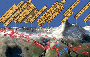
PeakNav drapes satellite imagery, OpenStreetMap trails and place names over a real elevation model of the whole planet. Fly over any range, tap a summit to orbit it, point your phone at the horizon to name the peaks in front of you, or open a photo and have it tagged with the...

Cost / License
- Free
- Open Source (GPL-3.0)
Since
- New
Updated
- Updated Oct 2026
Releases
- 6 releases last year6 last year
Platforms
- Mac
- Windows
- Linux
- Android
- iPhone
- Android Tablet
- iPad


Features
Highlights All activities
PeakNav News & Activities
Recent activities
- c17s5qhu liked PeakNav
- PeakNav updated PeakNav
- PeakNav added PeakNav
 PeakNav added PeakNav as alternative to PeakFinder AR, PeakVisor, PeakOrama, Hill Explorer and 4 more

Developed by
PeakNavLicensing
Open Source (GPL-3.0) and Free product.Written in
Alternatives
8 alternatives listedBadge
Get an embeddable badge for PeakNavSupported Languages

AlternativeTo Categories
Travel & Location, Sport & HealthGitHub repository
- 13 Stars
- 0 Forks
- 62 Open Issues
- Updated


No comments or reviews, maybe you want to be first?