OsmAnd Alternatives
OsmAnd is described as 'Navigation app with offline and online OSM maps, turn-by-turn voice guidance, cycling and driving modes, GPX tracking, POI search, and monthly updates' and is a very popular GPS Navigation service in the travel & location category. There are more than 100 alternatives to OsmAnd for a variety of platforms, including Android, iPhone, Web-based, iPad and Android Tablet apps. The best OsmAnd alternative is CoMaps, which is both free and Open Source. Other great apps like OsmAnd are Organic Maps, OpenStreetMap, Google Maps and Cartes.
Alternatives list

Cost / License
- Free
- Proprietary
Platforms
- Android
- iPhone


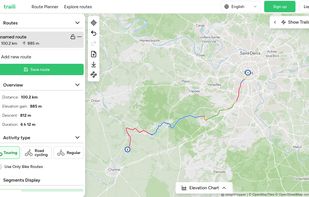
Traili Map combines a catalog of verified bike trails, an advanced planner, and a cycling community all in one platform. Bike route planning made easy.
Cost / License
- Free
- Proprietary
Platforms
- Online


Skill is a mobile app for downhill skiers and snowboarders. Now riding in a company and improving your skills becomes even more fun!.
Cost / License
- Free
- Proprietary
Platforms
- Android
- iPhone
- iPad


Value-based routing over API for Cars & Trucks uses cost factors to calculate routes and not minimizing distances; it uses a proprietary artificial intelligence model to estimate ETAs. Considering toll and multiple mandatory driving breaks. Available for Europe.
Cost / License
- Paid
- Proprietary
Application types
Platforms
- Software as a Service (SaaS)

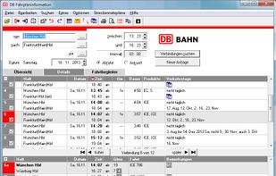
 17 DB Navigator alternatives
App by Deutsche Bahn (German Railways) to plan train/bus/metro trips, view current departures or delays, buy or display tickets, check-in, etc. Primarily for the German market but works in many European countries.
Cost / License
- Free
- Proprietary
Platforms
- Windows
- Android
- iPhone
- Apple Watch

 +1
+1


MapSCII is a mapping tool that enables users to explore geographic locations in a text-based format. It was specifically designed for visually impaired individuals who may have difficulty accessing and navigating traditional graphical maps.
Cost / License
- Free
- Open Source (MIT)
Platforms
- Linux
- Mac
- Windows
- Snapcraft


Offline desktop map viewer featuring vector OpenStreetMap data, navigation, GPX track import/export, elevation and contour display, customizable map layers, waypoint tools, and efficient handling of large files for outdoor, hiking, or off-road planning and navigation.
Cost / License
- Free
- Open Source
Alerts
- Discontinued
Platforms
- Linux


Modest Maps is a small, extensible, and free library for designers and developers who want to use interactive maps in their own projects. It provides a core set of features in a tight, clean package with plenty of hooks for additional functionality.
Cost / License
- Free
- Open Source
Platforms
- Mac
- Windows
- Linux


IDOS timetables websites is one of the outputs of the National information system of timetables (CIS JR), operated under auhority of Ministry of Transport of the Czech Republic by the company CHAPS Ltd.
Cost / License
- Free
- Proprietary
Platforms
- Online
- Android
- iPhone
- iPad


 +7
+7


GPS app featuring offline navigation across 100+ countries with compact storage usage, quick route calculation, 3D city maps, POIs, hands-free directions, and junction view for clarity on major roads, making it ideal for travelers seeking reliable, distraction-free guidance.
Cost / License
- Paid
- Proprietary
Application type
Platforms
- Android
- iPhone
- iPad
- Android Tablet


 +3
+3


Modest Map is a Javascript library, not a software/app such as Osmand (even though Osmand embeds an API)