OpenStreetMap Software

Browse 9 OpenStreetMap Software on AlternativeTo.

Copy a direct link to this comment to your clipboard
  1. Organic Maps icon
     193 likes

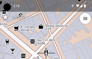
    Privacy-focused GPS app with offline maps and community development, featuring real-time navigation, no location tracking, and open-source software.

    Cost / License

    • Free
    • Open Source

    Platforms

    • Linux
    • Android
    • iPhone
    • Android Tablet
    • HUAWEI AppGallery
    • iPad
    • OpenStreetMap
    • Flathub
    • F-Droid
    Organic Maps screenshot 1
    Organic Maps screenshot 2
    Organic Maps screenshot 3
    50 alternatives
    4.4
    Very Good40 reviews
  2. StreetComplete icon
     44 likes

    Help to improve the OpenStreetMap with StreetComplete by completing quests which consists of simple questions about the world around you.

    Cost / License

    Application type

    Platforms

    • Android
    • Android Tablet
    • OpenStreetMap
    • F-Droid
    StreetComplete screenshot 1
    StreetComplete screenshot 2
    StreetComplete screenshot 3
    18 alternatives
  3. MAPS.ME icon
     114 likes

    MAPS.ME offers the quickest offline maps of all the countries of the world. Travel with full confidence: wherever you are, MAPS.ME addresses all your offline mapping needs.

    Cost / License

    Platforms

    • Android
    • iPhone
    • Android Tablet
    • iPad
    • OpenStreetMap
    • Kindle Fire
    MAPS.ME screenshot 1
    MAPS.ME screenshot 2
    MAPS.ME screenshot 3
    75 alternatives
  4. uMap icon
     34 likes

    uMap let you create maps with OpenStreetMap layers in a minute and embed them in your site. Add custom annotations, lines, shapes, import and add custom layers (KML, CSV, GPS, ...) and other data.

    Cost / License

    • Free
    • Open Source

    Application type

    Platforms

    • Self-Hosted
    • OpenStreetMap
    • Python
    • Django
    • Leaflet
    • Online
    uMap screenshot 1
    advanced editing features and right-click menu
    55 alternatives
  5. Kartaview icon
     18 likes

    KartaView is a free and open platform for street level imagery. Anyone can contribute images with a smartphone and the open source apps.

    Cost / License

    • Free
    • Proprietary

    Platforms

    • Online
    • Android
    • iPhone
    • OpenStreetMap
    • JavaScript
    • Leaflet
    Kartaview screenshot 1
    Kartaview screenshot 1
    Kartaview screenshot 2
    +1
    Kartaview screenshot 3
    9 alternatives
  6. FireYak icon
     1 like

    FireYak helps fire departments quickly find the nearest usable water source (e.g. fire hydrants, suction points, water tanks, fire water ponds, fire stations) based on OpenStreetMap data.

    Cost / License

    • Free
    • Open Source (MIT)

    Platforms

    • Online
    • Android
    • OpenStreetMap
    FireYak screenshot 1
    FireYak screenshot 2
    FireYak screenshot 3
  7. OSM Tasking Manager is a mapping tool designed and built for the Humanitarian OSM Team collaborative mapping. The purpose of the tool is to divide up a mapping job into smaller tasks that can be completed rapidly.

    Cost / License

    • Free
    • Open Source

    Platforms

    • Online
    • OpenStreetMap
    2 alternatives