Cost / License
- Free
- Open Source
Platforms
- Windows
- Linux
En esta lista intentamos explicar de forma cronológica y amena cómo hacemos nuestro trabajo. Si querés conocer nuestro sitio web con detalle técnico, te recomendamos que visites: https://w3techs.com/sites/info/arboladourbano.com https://www.similartech.com/websites/arboladourbano.com https://www.cubdomain.com/site/arboladourbano.com
Si bien acá presentamos nuestra dinámica en forma lineal, es muy frecuente que a veces utilicemos solo algunos de estos servicios o que volvamos hacia atrás porque se nos ocurrió una manera mejor de hacer las cosas. Esperamos que sea de utilidad para aclarar las dudas que tengas y, oportunamente, te puedas interiorizar en este apasionante mundo de árboles y mapas en el que nos encontramos. Que lo disfrutes!!!
PD: esta lista pretende ser exhaustiva, pero no está completa!!! Iremos agregando nuevos servicios a medida que los vayamos incorporando a la base de datos de este sitio web, que por cierto, deben ser aprobados por los moderadores.

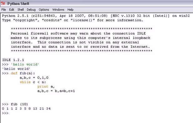
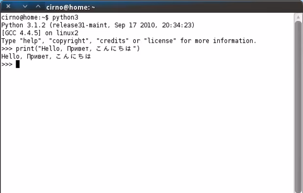
Python is an interpreted, interactive, object-oriented, extensible programming language. It provides an extraordinary combination of clarity and versatility, and is free and comprehensively ported.

Potlatch is the classic OpenStreetMap editor, combining an efficient user interface with attractive presentation and a number of powerful features.

Merkaartor is an OpenStreetMap editor for Unix, Windows and Mac OSX (prerelease, Intel only), distributed under the GNU General Public License.

Open source note-taking app with Markdown support, to-do integration, and synchronization with cloud services like Dropbox and OneDrive.


Help to improve the OpenStreetMap with StreetComplete by completing quests which consists of simple questions about the world around you.


Displays a country flag depicting the location of the current website's server. Using an offline database for arbitrary IP address to ISO country code. And provides utilities functions in right-click menu on button and also on webpage.


Vespucci is the first OpenStreetMap editor for Android. That means: It is a light-weight, easy-to-use mapping tool on mobile Android devices.


Google Chrome OS is a Linux-based operating system designed by Google that uses the ![]() Google Chrome web browser as its principal user interface, so it works primarily with web applications.
Google Chrome web browser as its principal user interface, so it works primarily with web applications.


Uber is Everyone's Private Driver. Use the Uber app to request a private car in any city the service is available. The app lets your driver know precisely where to pick you up, and lets you know exactly how long until they arrive.


The website openDesktop.org is a social networking site with main focus on the open source community. It centers on sharing of user generated contents such as applications and artwork with social components. openDesktop.


Uptodown is an international download site for mobile apps and desktop software. It was created on December 20, 2002, and is based in Málaga, Spain.


uMap let you create maps with OpenStreetMap layers in a minute and embed them in your site. Add custom annotations, lines, shapes, import and add custom layers (KML, CSV, GPS, ...) and other data.


Manage cities as a connected citizen (email & postal-code), it produces data for everyone about the registered cities.


Search engine that fights climate change. 60% of revenue each month goes to climate change charities involved in animal welfare, reforestation, ocean conservation, and climate action.


Get food delivery to your doorstep from thousands of amazing local and national restaurants. Find the meal you crave and order food from restaurants easily with the Uber Eats app. Track your order in real-time.


En esta sección se listan aplicaciones que dan una recompensa por realizar una actividad determinada. La ludificación de Arbolado Urbano estará orientada a la recolección colectiva y activa de datos de forma divertida, fomentando la competición entre los usuarios para que el usuario con la mejor clasificación sea el que más datos aporte. El usuario recibirá recompensas tanto tangibles, como árboles plantados por Ecosia, criptomoneda o dinero real, como recompensas intangibles, o sea pubtos, nivel, etc.


Travel between the real world and the virtual world of Pokémon with Pokémon GO for iPhone and Android devices. With Pokémon GO, you’ll discover Pokémon in a whole new world—your own!


MicMac is a free open-source (Cecill-B licence) photogrammetric suite that can be used in a variety of 3D reconstruction scenarios. In aims mainly at professionnal or academic users but constant efforts are made to make it more accessible to the general public.
La única forma de integrar el sitio con este buscador es comprándole a Presearch una suma mínima de PREs equivalente a 1 BTC, a su vez igual a 1.000.000 ARS. Luego de realizar la compra, los desarrolladores de Presearch agregan nuestro sitio a su metabuscador y le asignan etiquetas de SEO. Una forma que tal vez sería viable a muy largo plazo, sería solicitándole a nuestros usuarios que hagan sus búsquedas con el metabuscador de Presearch y nos transfieran sus PREs de su billetera a la nuestra.


Site that lets you compare the satellite imagery offered by NASA, Yahoo Maps, Microsoft Virtual Earth and more.

Explore Earth's vast landscapes and urban wonders with detailed satellite imagery, offline access, and ad-free experience.


Opticks is an expandable remote sensing and imagery analysis software platform that is free and open source. If you are interested you can learn about the history of Opticks.
Orfeo ToolBox (OTB) is an open-source C++ library for remote sensing images processing, distributed under the CeCILL-v2 license.
Salimos a la calle. Aprovechamos el tiempo que vamos a estar laburando afuera para hacer un poco de ejercicio y tomar un poco de sol y aire. Qué te parece una maratón en la que en vez de contar kilómetros corridos contás árboles relevados???
Nos fijamos cómo está el clima. No vaya a ser que nos lleve el viento (en la Patagonia) o nos quedemos nadando en la lluvia (CABA)!


La base para poder acceder a cualquier sitio web.


Nos (y les) preguntamos qué árbol encontramos, dónde, cuáles son sus características, etc.
Software de mensajería que permite utilizar chatbots, entre otros propósitos, para que el usuario de nuestro sitio web pueda rellenar formularios de forma interactiva y con un lenguaje natural.


Create online surveys or quizzes, gather information through personalized forms, and analyze responses automatically organized in linked spreadsheets.


Ejemplo: https://form.jotform.com/200454885233051
GPS: sí. i-Frame: sí. Sincronización con Google Drive: sí. Exportación de datasets: ? Precio: [agregar enlace]
El mejor y más completo servicio de formularios que existe. El problema es que al embeber MyMaps da el error x-Frame Options generado por los servidores de Google. Es una medida de seguridad muy restrictiva para evitar ataques cruzados. Detalles del error: https://developer.mozilla.org/en-US/docs/Web/HTTP/Headers/X-Frame-Options


Ejemplo: http://www.123formbuilder.com/form-5386141/form
GPS: SI (coordenadas detectadas automáticamente mediante usando una API key propia de Google Cloud). https://developers.google.com/maps/documentation/javascript/get-api-key Problema: no puedo configurar el mapa. i-Frame: versión paga. Sincronización con Google Drive: no. Exportación de datasets: sí https://www.123formbuilder.com/docs/how-to-export-all-of-my-submissions-to-csv/ Precio: https://www.123formbuilder.com/signup.html


Ejemplo: https://app.zyncfreesurveys.com/?u=erb18k8sh1rpo&s=14oj348k8v32yt4
GPS: SI. i-Frame: no. Sincronización con Google Drive: no. Exportación de datasets: sí. Ayuda: https://desk.zoho.com/portal/zyncfreesurveys/kb/articles/getting-started#Now_lets_share_this_survey_with_a_friend Precio: https://www.zyncfreesurveys.com/


Ejemplo: https://enketo.ona.io/x/#f2kN7nyf
GPS: SI. i-Frame: no (parcialmente sustituído con un Mapbox integrado en el formulario). Exportación: https://help.ona.io/knowledge-base/submission-review/ Precios: https://ona.io/plans.html Problemas: En el teléfono las submissions son tomadas como privadas, más allá de que el formulario esté configurado como público?! La descripción del servicio gratuito no es coherente con la forma en que realmente funciona, supuestamente la sincronización con Google Sheets no está disponible, pero en realidad lo está?!


Juntamos los datasets acá para que puedan ser accesibles por cualquiera, sin que tengan que esperar a que estén cargados en nuestro sitio web.
Cloud service for file storage and sync, integrated with Google Docs suite, facilitating collaboration and offering scalable storage solutions.


