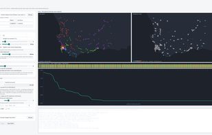
Trekplan is a Windows desktop route planner for teams that visit many fixed sites: telecom masts, meters, farms, stores, inspection points. It reads any CSV or Excel list of GPS points, detects the columns automatically, and turns the list into optimised multi-day field routes: sites grouped into day-routes, the day-routes split across teams and depots, and the total driving reduced by an optimiser that runs live on screen.
The planner sets the rules: sites per day, the maximum distance between sites on one route, the number of teams, optional team base stations, and optional overnight trips that are only used where they cost less than driving home. With a cost per kilometre and per night, the plan is priced in the local currency.
Outputs: an Excel plan (dashboard, one row per route, one row per stop in visit order), a Google Earth KML map, and GPX files for handheld GPS units, one per team, so each crew only receives its own routes.
Example: 520 public mast sites from OpenStreetMap became 184 day-routes for 6 teams in about 3 seconds, with 209 km of driving removed (sample data © OpenStreetMap contributors).
Site data stays on the PC: no account, no sign-in, no telemetry. Distances are straight-line estimates by default; real road distances are optional through the user's own free OpenRouteService key. The same input always produces the identical plan. Decimal degrees, degrees-minutes-seconds, comma decimals and semicolon CSVs all load; kilometres or miles.
Trekplan is a one-time purchase rather than a per-vehicle monthly subscription, with a 15-day free trial in the Microsoft Store.







 Corne Fick


No comments or reviews, maybe you want to be first?