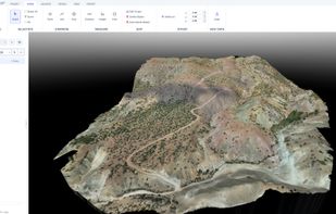
STREAM is a native Windows desktop application for visualizing, measuring and analyzing drone-mapping and GIS terrain data. It loads large DEMs/DSMs, orthophotos, CAD drawings (DXF) and point clouds (LAS/LAZ) and renders them in a smooth, GPU-accelerated 3D environment with adaptive streaming — multi-gigabyte datasets stay fluid and interactive at full resolution, with no downsampling.
Data import & layers
Import GeoTIFF elevation and orthophoto rasters, DXF vector drawings and LAS/LAZ point clouds (rasterized on import to ground DEM, surface DEM or orthophoto). Stack multiple DEMs and orthophotos in a single project with per-layer visibility, opacity and priority. Coordinate system (CRS) handling with on-the-fly reprojection, and fast native caching so projects reopen instantly.
Measurement & drawing
Points, 3D polylines with elevation profiles, area polygons, distance/height/area measurements — all draped precisely on the terrain with snapping, editable coordinates and animated, easy-to-read labels.
Terrain analysis
Slope, aspect, viewshed and line-of-sight analyses, contour generation, hydrology tools (flow paths, watersheds), sun & shadow analysis and change detection between two surveys — computed at full resolution and displayed as live overlays on the 3D terrain.
Volumes & earthworks
Cut/fill volume computation against multiple reference surfaces, stockpile management with a material library and print-ready PDF reports, and cross-section based volume tables exported to CSV/Excel and DXF.
Design modules
Road and corridor design with horizontal alignment (circular curves and clothoid transitions), vertical profile, typical section with superelevation, cross-sections and a mass haul view. Grading and benched slopes: find the platform elevation where cut equals fill, set bench height, berm width and batter angle, and compute the daylight line against the surveyed ground. Blast pattern design on a surveyed bench with collar elevations read from the DEM, burden relief measured in 3D against the free face, and a hole table exported to Excel/CSV.
Terrain editing & scenarios
Flatten, patch and re-triangulate terrain areas non-destructively — edits live in the project and can be exported baked into GeoTIFF. Keep multiple terrain scenarios (before/after, design alternatives) in one project and switch between them instantly.
Export & reporting
DXF (including TIN surfaces), point CSV, area-cropped GeoTIFF, contour DXF, KMZ, and professional PDF map sheets and reports.
Everything runs offline — the data never leaves the machine. STREAM is built for surveyors, mining and construction teams, and drone-mapping professionals who need CAD/GIS-grade measurement, analysis and reporting in one fast, focused tool. The interface is fully translated into 6 languages (English, Turkish, Spanish, French, Chinese, Russian) and supports both metric and imperial units. Academic use is always free.






 StreamTerrrain added Stream Terrain as alternative to Global Mapper and Surfer
 STREAM
No comments or reviews, maybe you want to be first?