Route Companion icon

Route Companion

Route Companion is a phone app for long rides and runs. Import a route from Strava, Ride with GPS or a GPX file, or plan one in the app, and it finds the stops along it from OpenStreetMap: water, shops, cafés, restaurants, toilets, bike shops and more.
Route Companion screenshot 1
Route Companion screenshot 2
+7
Route Companion screenshot 3

Cost / License

  • Freemium (Pay once or Subscription)
  • Proprietary

Platforms

  • iPhone
  • iPad
0likes
0articles
Save

Features

  1.  Dark Mode
  2.  Hiking Maps
  3.  Route Planning
  4.  Ad-free
  5.  No Tracking
  6.  Turn-by-turn Navigation
  7.  Works Offline
  8.  Cycling
  9.  No registration required
  10.  Nearby Search
  11.  Points of Interest (POI)
  12.  Garmin
  13.  Based on OpenStreetMap
  14.  Strava
  15.  GPS Navigation

Route Companion News & Activities

Highlights All activities

Recent activities

Route Companion information

  • Developed by

    CH flagRoute Companion
  • Licensing

    Proprietary and Freemium product.
  • Pricing

    One time purchase that costs $29, and / or subscription ranging between $2 and $15 per month + free version with limited functionality.
  • Alternatives

    4 alternatives listed
  • Badge

    Get an embeddable badge for Route Companion
  • Supported Languages

    • English
    • German
    • French

AlternativeTo Categories

Travel & Location, Sport & Health

Popular alternatives

View all
Route Companion was added to AlternativeTo by florist_gump on and this page was last updated .

No comments or reviews, maybe you want to be first?

Official Links

What is Route Companion?

Route Companion is a phone app for long rides and runs. Import a route from Strava, Ride with GPS or a GPX file, or plan one in the app, and it finds the stops along it from OpenStreetMap: water, shops, cafés, restaurants, toilets, bike shops and more.
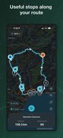
For each stop it shows how far ahead it is, how far off the route, and whether it will be open when you arrive, based on your pace from recent rides and the climbing ahead. Once you start riding, the arrival times update from your position and speed. If a stop shuts before you get there, it points to the next one on the route that will be open.

You can send the route with the stops to a Garmin or Wahoo. Stops without opening hours in OpenStreetMap are shown without an open or closed verdict, and riders can report a wrong or closed stop so others see a warning