Apps with 'Waypoints' feature

All apps in Apps with 'Waypoints' feature category. Use the filters below to narrow down your search. 
Copy a direct link to this comment to your clipboard
  1. MAPS.ME icon
     113 likes

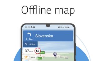
    MAPS.ME offers the quickest offline maps of all the countries of the world. Travel with full confidence: wherever you are, MAPS.ME addresses all your offline mapping needs.

    MAPS.ME screenshot 1
    MAPS.ME screenshot 2
    MAPS.ME screenshot 3
    75 alternatives
  2. Navigr8 is a top alternative to cycling computers. It offers a customizable dashboard, navigation with auto-routing & turn-by-turn, connects to various sensors including Varia radar, and more. Available on iPhone & Apple Watch. Free with a Pro version for advanced features.

    • FreemiumProprietary
    • iPhone
    • Apple Watch
    Navigr8 : Bike Computer screenshot 1
    Navigr8 : Bike Computer screenshot 2
    Navigr8 : Bike Computer screenshot 3
  3. GpsPrune icon
     7 likes

    GpsPrune is an application for viewing, editing and converting coordinate data from GPS systems. Basically it's a tool to let you play with your GPS data after you get home from your trip.

    • FreeOpen Source
    • Mac
    • Windows
    • Linux
    • OpenJDK
    GpsPrune screenshot 1
    18 alternatives
  4. Mobile Trail Explorer is an application where user can view and record tracks using the mobile phone and GPS device (either external or internal). Recorded tracks can be exported in KML or GPX formats so that they can be viewed in Google Earth application.

    • FreeOpen Source
    • Java Mobile
    screenshot E71
    19 alternatives
  5. Mapwel icon
     Like

    Mapwel was designed to be used for custom GPS maps creation by both professionals and hobbyists.

    • PaidProprietary
    • Windows
    Mapwel screenshot 1
    2 alternatives