TourGaze icon
TourGaze icon

TourGaze

Local-first ride viewer — import, browse, tag, replay, compare and analyse your tours. TourGaze turns the FIT / GPX / TCX / KMZ files from your bike computer, watch or phone into a searchable, taggable library of rides — with a cinematic map replay, advanced per-ride analytics...
TourGaze screenshot 1

Cost / License

Platforms

  • Windows
  • Linux
  • Docker
  • Self-Hosted
  • Java
  • Node.JS
1like
0comments
0articles

Features

Properties

  1.  Privacy focused

Features

  1.  Dark Mode
  2.  Works Offline
  3.  Cycling
  4.  No Tracking
  5.  Ad-free
  6.  Record and replay
  7. OpenStreetMap icon  Openstreetmap integration
  8.  Supports GPX Export
  9.  Trace Route

TourGaze News & Activities

Highlights All activities

Recent activities

TourGaze information

  • Developed by

    Unknown
  • Licensing

    Open Source (AGPL-3.0) and Free product.
  • Written in

  • Alternatives

    21 alternatives listed
  • Supported Languages

    • English

AlternativeTo Categories

Backup & SyncSport & Health

GitHub repository

  •  7 Stars
  •  0 Forks
  •  2 Open Issues
  •   Updated  
View on GitHub
TourGaze was added to AlternativeTo by Paul on and this page was last updated .
No comments or reviews, maybe you want to be first?

What is TourGaze?

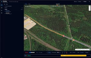
Local-first ride viewer — import, browse, tag, replay, compare and analyse your tours. TourGaze turns the FIT / GPX / TCX / KMZ files from your bike computer, watch or phone into a searchable, taggable library of rides — with a cinematic map replay, advanced per-ride analytics, a ghost-chase compare mode, geo-matched photos, and a JIRA-style faceted search across everything. It all runs on your machine; your data never leaves it.

Features:

  • Import FIT, GPX, TCX and KMZ/KML (OpenTracks) — drop into the inbox, or let the Garmin device auto-scan pick up new .fit files. Import pre-fills a sensible activity type and guesses the gear from your past similar rides.
  • Browse & filter with a faceted mini-language: sport:cycling year:2014..2018 gear:"Race Bike" tag:alpine dist:>50.
  • Hierarchical tags (a parent matches all descendants), drag-to-apply, recursive filtering.
  • Gear (bikes / shoes / …) with per-gear stats and bulk-assign across filtered rides.
  • Cinematic replay — drone / helicopter / follow / top-down cameras (precomputed, buttery-smooth path; the drone steers by your general direction), with a rider marker, HR/slope-coloured track, photo fades — and a little rain animation when you ride through a detected shower.
  • Ride events — typed moments pinned on the replay map: rain showers are auto-detected on import from the weather along your track, and you add your own (drink break, puncture, viewpoint, …) by clicking the map. Event kinds are user-managed masterdata (name + icon + colour) in Settings.
  • Custom attributes — annotate any ride with free-form key/values (stored as JSON), editable in an Events tab on the ride.
  • Elite stats — best efforts, climbing & VAM, gradient distribution, HR zones, training load (TRIMP), aerobic decoupling, estimated cycling power (NP / VI) and calorie burn (mechanical work when power is present, otherwise a Keytel heart-rate estimate).
  • Raw data view — every channel a ride recorded (elevation, HR, speed, cadence, power) as per-channel charts and a virtualised table of all samples, with the ride's summary totals; the per-ride sensor set is detected on import. Reached from the Raw link in the viewer.
  • Compare (ghost-chase) — finds rides on the same route (GPS overlap, of a comparable length) and races them: a live HUD (distance / time / HR gap) and a Mario-Kart off-screen arrow when a ghost leaves the viewport.
  • Markers — global points of interest (food, viewpoint, peak, …) with categories and an editable description, shown on the map and a filterable list with click-to-jump (a ride only shows the markers near its route).
  • Photos & video — drop your own (geo-matched by EXIF, shown as map pins, faded in during replay, in a gallery), or auto-discover Creative-Commons photos along the route from Wikimedia Commons. Public vs personal are clearly labelled; big uploads are downscaled (EXIF preserved).

Official Links