topograph Alternatives
topograph is described as 'Topograph turns real elevation data into clean, customizable topographic graphics. Generate from data, upload your own sources, or search any location. Adjust contour density, styles, and color, then export as SVG, PNG, PDF, GeoJSON, DXF, or STL. Runs client-side' and is a Map service in the photos & graphics category. There are more than 50 alternatives to topograph, not only websites but also apps for a variety of platforms, including Android, Mac, Self-Hosted and Windows apps. The best topograph alternative is Google Maps, which is free. Other great sites and apps similar to topograph are QGIS, OpenFreeMap, GMaps WV and Mapiful.
Alternatives list
 31 ZeeMaps alternatives
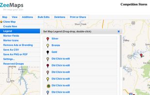
Use ZeeMaps to create, make, and publish interactive, customized maps. Make a map of places you have visited, your customers, friends, or relatives. Create a map of garage sales or crimes in your neighborhood, map your news story or wedding location.
Cost / License
- Freemium
- Proprietary
Platforms
- Online


MapServer is an Open Source platform for publishing spatial data and interactive mapping applications to the web. Originally developed in the mid-1990’s at the University of Minnesota, MapServer is released under an MIT-style license, and runs on all major platforms (Windows...


Google Maps API is a collection of APIs that enable you to overlay your own data on a customized Google Map. You can create engaging web and mobile applications with Google’s powerful mapping platform including satellite imagery, street view, elevation profiles, driving...
Cost / License
- Freemium
- Proprietary
Platforms
- Online


Map3 is a decentralised map network that is impartial, secure and extremely robust. It is free from control, free to participate, free base map. It is built to be governed by the Map3 community where individuals and organisations can host Map3 nodes.


Offline navigation app providing worldwide maps from OSM, using Mapsforge-vtm for map display, Graphhopper for multi-mode routing, downloadable maps, turn-by-turn navigation, address search, privacy focus, no ads, lightweight interface, and community-supported updates.
 +6
+6


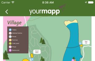
YourMapp lets you turn your custom maps into an interactive app. Add hotspots to image-based maps, linking to more and information. Embed it on the web or create a branded app with features such as geolocation, offline storage and push notifications.

 +6
+6


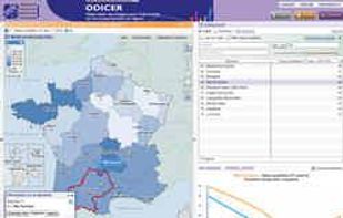
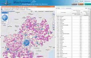
The Géoclip interactive mapping solution is proposed by EMC3. Géoclip permits to publish online thematic atlas or territorial observatories. Géoclip allows you to build web mapping applications for cartographic representations of statistical data.


Map Maker is a powerful but easy-to-use Web application for creating custom maps. You can upload your data, customize how the data is visualized, then export the map or share it with others for editing.


Visualize your local tech startup community on a custom Google Map. Host everything locally on your own server, or optionally show data from Startup Genome.


