

Therion
Therion is a complete package which processes survey data and generates maps or 3D models of caves. It runs on wide variety of platforms: Linux, Windows, Mac OS X. It is completely free, released under the terms of GNU GPL, with source code available.

Features
- Map Maker
Tags
- Mapping
- 3d-models
- cave-cartography
- therion
- 3d-maps
- survey-data
- cave-map
- cartography
Therion News & Activities
Recent activities
Therion information
Developed by
TherionLicensing
Open Source (GPL-2.0) and Free product.Written in
Alternatives
2 alternatives listedSupported Languages
- English

AlternativeTo Categories
Travel & Location, Photos & GraphicsGitHub repository
- 112 Stars
- 49 Forks
- 107 Open Issues
- Updated

What is Therion?
Therion is a complete package which processes survey data and generates maps or 3D models of caves. It runs on wide variety of platforms: Linux, Windows, Mac OS X. It is completely free, released under the terms of GNU GPL, with source code available. It doesn't require any other commercial software to run.
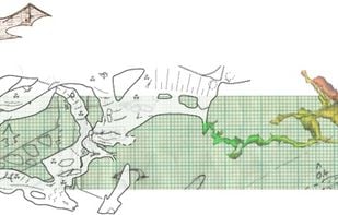
Therion solves the most annoying problem of cave cartography – how to keep a map of large and complicated cave system always up-to-date. Main features include:
- Complete maps with all the detail. No additional ink stroke is needed.
- Maps are dynamic, always up-to-date – i.e. they are automatically re-drawn after loop closure, blunder fix, scale or symbol set change.
- 3D models are created using 2D maps.
Other projects with similar goals are Tunnel, GHTopo, Walls and Compass.
Therion is especially suitable for documenting large and complicated cave systems. Therion has been used in various projects in Europe, Americas and Asia-Pacific regions.
Without Therion most of the caves listed above would have no usable map: only a lot of partial maps, sketches and notes which nobody would be able to put together.