





Terralog
Like
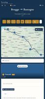
An offline travel journal for planning routes, recording GPS tracks, notes, photos, videos and audio, and finding nearby services. It supports encrypted sharing without accounts, live alerts, budgets, weather, map apps, multiple trip views, and exports to albums, PDFs, Markdown or standalone archives.



+11

 EU
Platforms
- Online
- Android
- iPhone
- iPad

Features
Highlights All activities
Terralog News & Activities
Recent activities
 Danilo Venom added Terralog as alternative to Stopful, Travel Scan, Plan Harmony, Plux and 9 more
- Danilo Venom updated Terralog
- Mekaoui-Helmy added Terralog
 Mekaoui-Helmy added Terralog as alternative to Polarsteps and FindPenguins


Developed by
 Threshold‑Analytics
Licensing
Proprietary and Freemium product.Pricing
Subscription that costs $30 per year + free version with limited functionality.Alternatives
15 alternatives listedBadge
Get an embeddable badge for TerralogSupported Languages


No comments or reviews, maybe you want to be first?