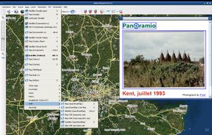
This program allows work with any maps service if you can describe getting picture by longitude/latitude(if you want you can write config file or simplepascal script to describe how obtain needle photos).


OpenStreetMap is described as 'Browse, search and edit worldwide map data for roads, paths, places, buildings and natural features, then reuse it under an open data licence' and is a leading Map service in the travel & location category. There are more than 100 alternatives to OpenStreetMap, not only websites but also apps for a variety of platforms, including Android, iPhone, iPad and Android Tablet apps. The best OpenStreetMap alternative is CoMaps, which is both free and Open Source. Other great sites and apps similar to OpenStreetMap are Organic Maps, OsmAnd, Google Maps and Google Earth.
This program allows work with any maps service if you can describe getting picture by longitude/latitude(if you want you can write config file or simplepascal script to describe how obtain needle photos).


Get FREE Driving Directions between any point (address, city, state, zip code, or GPS Coordinates) shown on Google Maps™ and follow the turn-by-turn directions that will be displayed below the map.

Explore developer resources and start building your own applications using Planet's data and tools. Transform daily satellite imagery into intelligent analytic feeds to index objects and change.
Modest Maps is a small, extensible, and free library for designers and developers who want to use interactive maps in their own projects. It provides a core set of features in a tight, clean package with plenty of hooks for additional functionality.


Community platform enabling contributions to global location-based experiences, supporting shared place accuracy for millions, tiered member levels, developer integration, and participation in feedback, innovation, and worldwide mapping initiatives.


Quickly search for locations directly from your Mac’s menu bar and open them in Apple Maps, Google Maps, or OpenStreetMap.


Android navigation app with high-quality offline HD maps, voice-guided turn-by-turn directions, speed and lane guidance, POI search by category, supports driving, biking and walking, automatic rerouting, itinerary planning, and multilingual interface for travelers.


Maverick is a GPS off-road navigation app for Android devices. It automatically caches all your maps for offline use so that you can access them even without an Internet connection. This app is great for hiking, boating, geocaching, and other outdoor activities.


Maximize the use of your Excel spreadsheet data. Make mapping the easiest. Transform Excel data into visual analysis. We lead in data simplification and presentation. We are committed to deliver the tools needed to outpace competition.


Google Maps Go, the lighter version of the original Google Maps app. Designed to run smoothly on devices with limited memory and on unreliable networks without compromising speed to provide your location, real-time traffic updates, directions, and train, bus, and city transit...


Offline desktop map viewer featuring vector OpenStreetMap data, navigation, GPX track import/export, elevation and contour display, customizable map layers, waypoint tools, and efficient handling of large files for outdoor, hiking, or off-road planning and navigation.