

Mini5Planner icon
Mini5Planner icon

Mini5Planner

 Like

Mini5Planner is a desktop app for Mac and Windows that plans photogrammetry and mapping flights for DJI drones that fly waypoint missions in DJI Fly. It is made for drones where third-party flight apps can't take control, such as the DJI Mini 5 Pro, Air 3, Air 3S, Mavic 3...
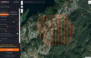
Double grid (crosshatch) with the Excavation site template: 50 m altitude, 85/75 % overlap and an oblique gimbal for 3D.

Cost / License

  • Freemium (Pay once)
  • Proprietary

Since

  • New

Platforms

  • Windows
  • Mac
0likes
0articles
Save

Features

No features, maybe you want to suggest one?

Highlights All activities

Mini5Planner News & Activities

Recent activities

Mini5Planner information

  • Developed by

    NO flagAnleggtech AS
  • Licensing

    Proprietary and Freemium product.
  • Pricing

    One time purchase (perpetual license) that costs $19 + free version with limited functionality.
  • Alternatives

    2 alternatives listed
  • Badge

    Get an embeddable badge for Mini5Planner
  • Supported Languages

    • English
    • Norwegian

AlternativeTo Category

Travel & Location
Mini5Planner was added to AlternativeTo by Torstein-Olsen on and this page was last updated .

No comments or reviews, maybe you want to be first?

What is Mini5Planner?

Mini5Planner is a desktop app for Mac and Windows that plans photogrammetry and mapping flights for DJI drones that fly waypoint missions in DJI Fly. It is made for drones where third-party flight apps can't take control, such as the DJI Mini 5 Pro, Air 3, Air 3S, Mavic 3, Mavic 3 Pro and Mavic 4 Pro. The Mini 4 Pro is also supported.

Draw the area on the map and choose a single grid or a double grid (crosshatch). Set altitude, front and side overlap, speed, gimbal angle and flight direction. Ground sample distance, photo footprint, photo count, flight time, distance and estimated battery use update while you adjust. Flight speed is limited by how fast the camera can save each photo, so the planned overlap is the overlap you get.

The route is exported as a standard WPML 1.0.2 KMZ file. A built-in guide shows how to copy it to the DJI RC 2 over USB-C on Mac and Windows, so the mission can be flown as a normal waypoint mission in DJI Fly. After the flight, the app can check the photos and show where the overlap was too low.

The free version includes all seven drones and both grid types. An optional one-time Pro license adds terrain following (Kartverket's 1 m elevation model in Norway, Copernicus GLO-30 elsewhere) and battery splitting (one KMZ per battery).

The photos can be processed into orthophotos, point clouds and 3D models in photogrammetry software such as OpenDroneMap/WebODM, Pix4D or Metashape. English and Norwegian interface, templates and automatic updates.

Mini5Planner is an independent product and is not affiliated with or endorsed by DJI.