You get home with some photos, a couple of clips and a GPS track nobody is ever going to scroll through. How It Went turns all three into a short film that follows your route — one ride, or a whole trip with the rest days still in it.
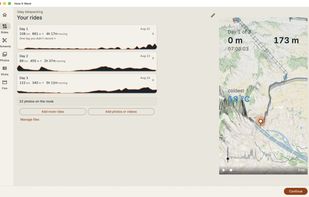
The route is the film. Your track draws itself across a tilted map, your photos appear at the spot on the route where you took them, and your clips play where they were shot. Underneath, the day's numbers — distance, elevation gain, moving time — read as narration.
That's the part a slideshow can't do. A slideshow fails on exactly the day you most want to keep: the long solitary one where you were too tired to take pictures. The track is the only thing recorded densely enough to carry a day on its own.
WHAT YOU BRING
- Rides picked straight from your Strava account
- Or the files themselves: Garmin FIT, including the zipped "Export Original" archive you download from Garmin Connect, and GPX
- One ride, or a whole trip at once. Several activities merge into one film, day by day, and rest days stay in as rest days instead of getting dropped
- Photos, placed along the track by the time they were taken
- Action-cam and drone clips, with more than one moment pulled out of a single recording — a four-minute file usually holds two or three keepers, not one
A ride arrives through another app's share sheet, from Files, or dragged onto the window on a Mac.
WHEN THE CAMERA CLOCK WAS WRONG
An action cam that was never set to local time will drop your lunch stop in the wrong valley, and you can't tell by looking at the photo. Fix the clock once and everything shot on that camera moves together. Anything still out of place can be dragged where it belongs, and it stays put while you keep editing.
The times in your film are the times you rode at, not the times where you're sitting now. Edit after you've flown home and a photo taken at 1:30 still says 1:30.
WHAT COMES OUT
An ordinary video file — 9:16 for Instagram and TikTok, or 16:9 for YouTube. It's put together on the device in your hands, phone or Mac, so you can post it the evening you get in.
Map data from OpenStreetMap contributors.







 EU
EU


 hpoul added How It Went as alternative to TrekReel, OVRLEY, Cyclemetry and Telemetry Overlay
 CodeUX.design e.U.