




GeoAddIn
Like
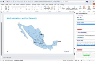
GeoAddIn is a PowerPoint extension that lets users add fully editable geographic maps directly within PowerPoint. Maps can combine several countries and display sub-national levels, as well as mark city and airports.

Cost / License
- Subscription
- Proprietary
 EU
EUPlatforms
- Windows
- Microsoft PowerPoint



Features
GeoAddIn News & Activities
Highlights All activities
Recent activities
- Paul Ploumhans added GeoAddIn
 Paul Ploumhans added GeoAddIn as alternative to Power-user and think-cell chart

GeoAddIn information
Developed by
 Arvestria SRL
 Licensing
Proprietary and Commercial product.Pricing
Subscription that costs $136 per year.Alternatives
2 alternatives listedBadge
Get an embeddable badge for GeoAddInSupported Languages

No comments or reviews, maybe you want to be first?