EXIF360
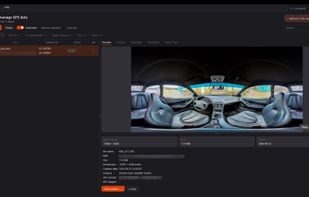
Windows tool for lossless GPS tagging of JPG, RAW, and equirectangular 360° panoramas. It matches timestamps to GPX tracks or lets users place photos on a map, corrects heading, pitch, and XMP metadata in batches, then uploads and links images as Street View tours.
Cost / License
- Freemium (Pay once)
- Proprietary

Platforms
- Windows
Features
Properties
- Privacy focused
Features
- Dark Mode
- Ad-free
- No registration required
- Built-in viewer
- Street View
- No Tracking
- Geotagging
- Batch Editing
- Works Offline
- EXIF Editing
EXIF360 News & Activities
Recent activities
- Danilo_Venom updated EXIF360
- Jennifer-Nitz added EXIF360
Luca-Trombetta added EXIF360 as alternative to GeoTaggami: GPS Photo EXIF Map- Jennifer-Nitz added EXIF360 as alternative to GPicSync, Geotag, Geotagger and Photogpseditor
EXIF360 information
What is EXIF360?
EXIF360 is a software tool that addresses issues faced when working with Google Street View, such as panoramas being rejected as "indoor", unsuccessful uploads due to incorrect metadata, and lack of GPS information in photos from 360° videos. The software offers lossless geotagging, ensures image data is never re-compressed, and includes a built-in map feature for setting positions. It also provides GPX track matching for automatic geotagging, supports Street View publishing, and offers orientation control. Users can list, re-orient, and delete previously published photos from within the app. EXIF360 includes a backup and undo feature, and respects user privacy, with all image data remaining on the user's machine and no tracking or telemetry. An account is only required for Street View upload.


