




WhereWasTaken
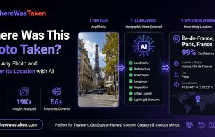
WhereWasTaken is an AI image location finder that helps you discover where photos were taken using visual clues.

Cost / License
- Freemium (Subscription)
- Proprietary
Platforms
- Online

Features
- Machine Learning Analyze
WhereWasTaken News & Activities
Recent activities
- llisonly added WhereWasTaken
 llisonly added WhereWasTaken as alternative to GeoSpy, Picarta, FindPicLocation and Where Is This Photo?

WhereWasTaken information
Licensing
Proprietary and Freemium product.Pricing
Subscription ranging between $6 and $20 per month + free version with limited functionality.Alternatives
4 alternatives listedBadge
Get an embeddable badge for WhereWasTakenSupported Languages
- English
- Chinese


What is WhereWasTaken?
WhereWasTaken — AI Image Geolocation Engine Overview
WhereWasTaken is an AI-powered image geolocation engine that helps you discover where photos were taken using visual clues instead of GPS or EXIF metadata.
Upload any image, travel photo, landmark picture, or GeoGuessr screenshot. Our AI analyzes geographic signals such as landmarks, architecture, roads, signs, vegetation, and landscapes to identify the most likely location.
Each analysis provides a complete location report with the predicted place, confidence score, interactive map, geographic evidence, and alternative location candidates.
Key Features AI Image Geolocation
Find photo locations without GPS or EXIF data. AI vision technology analyzes images to estimate countries, regions, cities, and possible locations.
Visual Clue Intelligence
Detect geographic signals including:
Landmarks and signs Architecture and buildings Roads and infrastructure Vegetation and terrain Regional visual patterns GeoGuessr Image Solver
Analyze GeoGuessr screenshots and game rounds with AI-powered geographic reasoning. Learn how environmental clues can reveal locations.
Location Reports
Get detailed results including:
Most likely location Confidence score Interactive map Geographic evidence Alternative candidates Global Location Discovery
Explore unknown places around the world through AI-powered image understanding.
Use Cases GeoGuessr Coaching
Improve your GeoGuessr skills by analyzing screenshots and learning location deduction techniques.
Photo Location Discovery
Find where photos were taken without GPS or metadata, including travel photos, old images, screenshots, and unknown locations.
OSINT Image Investigation
Analyze online images and investigate possible origins using AI geographic reasoning.
Reverse Location Search
Discover image locations when traditional reverse image search tools cannot provide answers.
Geographic Education
Learn how landscapes, architecture, and infrastructure reveal information about places.
Getting Started
-
Upload an Image Upload any JPG, PNG, WEBP image, travel photo, landmark image, or GeoGuessr screenshot.
-
AI Analyzes Geographic Clues The system examines visual details including landmarks, roads, architecture, signs, and environmental features.
-
Receive Your Location Report Get the predicted location, confidence score, map, evidence explanation, and alternative possibilities.
Pricing & Plans
WhereWasTaken offers flexible AI image geolocation services.
Free Plan Explore image locations with essential AI analysis features.
Pro Plan Unlock deeper geographic insights, detailed evidence, enhanced analysis capabilities, and advanced location reports.
Discover where any image was taken with AI-powered geographic intelligence. Upload a photo and let WhereWasTaken reveal the location hidden inside.