


Treweler
Like
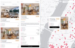
Treweler is a WordPress plugin based on the Mapbox platform that allows users to build customizable interactive maps for websites. It is intended for developers, businesses, and individuals who work with location-based data and need a way to display and manage it within...

Cost / License
- Pay once
- Proprietary
Platforms
- Wordpress


Features
Highlights All activities
Treweler News & Activities
Recent activities
- Paul updated Treweler
- aisconverse added Treweler
 aisconverse added Treweler as alternative to StoreRocket Store Locator, StoreLocatorWidgets Store Locator, Mapular Store Locator and Storepoint Store Locator

Developed by
 Aisconverse
Licensing
Proprietary and Commercial product.Pricing
One time purchase (perpetual license) ranging between $39 and $1499.Alternatives
4 alternatives listedBadge
Get an embeddable badge for TrewelerSupported Languages


No comments or reviews, maybe you want to be first?