The tide and currents app that works without signal. Tides for more than 4,700 stations worldwide and currents across the US and Canada, already on your phone — on the water, on the beach, in the anchorage, with no bars and nothing to load.
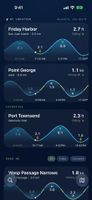
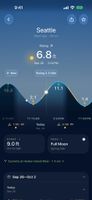
No spinner. No "no internet connection". You open it, and the answer is there: rising or falling, flooding or ebbing, and how long until the next high, low or slack.
And it does the part most tide apps skip. Heights are the easy half. The harder question is the current: when does the pass go slack? How hard is it running at max? Can you get through before it turns?
WORKS WHERE THERE IS NO SIGNAL
Predictions are made on your phone, not fetched. Down a dead-end road, out at the point, in an anchorage, or with the boat's electronics down — you get the same answer you would have got at the dock. The map for your area and your favourite stations stays on your phone too.
CURRENTS, NOT JUST TIDES
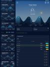
Slack, max flood and max ebb on one curve, with speed and direction. Drag your thumb across the week to read any moment. Every current station links to the tide at its reference port.
SUN, MOON AND THE TIDES THEY DRIVE
Sunrise, sunset and twilight, the moon's phase, spring and neap tides explained, and solar and lunar eclipses, for every station.
ON YOUR WRIST, HOME SCREEN AND SIRI
An Apple Watch app that works without your phone: turn the Digital Crown to scrub the day. Home screen widgets for the next event and today's curve. Ask Siri for the next low tide, high tide or slack window. On iPhone and iPad, in 14 languages.
FREE, NO ACCOUNT, NO ADS
Every station and every date is free and stays free. No account, no ads, no tracking, and the app is open source.
Slackwater Premium is optional and funds development: lock screen widgets, Apple Watch complications, alerts before the tides and currents you care about, and station calendars. Choose a yearly subscription or a one-time lifetime purchase.
WHERE THE NUMBERS COME FROM
Tides for more than 4,700 stations across a hundred countries are built in, from NOAA, the Canadian Hydrographic Service, Norway's Kartverket and the TICON-4 global tide-gauge catalogue, and checked against each station's published tidal datums wherever it has them. Currents cover the United States and Canada: more than 2,500 NOAA current stations, plus 22 Canadian passes from the Salish Sea to Haida Gwaii and Cape Breton. Canadian stations download their data from the Canadian Hydrographic Service once, then work offline. A few Canadian passes sit in water the on-device model cannot predict; those fetch predictions when you are online, and say so. Where we cannot publish numbers we trust, the station is listed but blank instead of guessed.
Predictions are not observations — conditions vary with weather and river flow. Not for navigation.








 clarkbw added Slackwater Tides & Currents as alternative to Slackwater

 Open Water Software LLC


No comments or reviews, maybe you want to be first?