
Top Survey GPS map camera
Top survey is an App which can help while surveying on the field by a finely crafted camera having all the requisites in support of surveyors.
Cost / License
- Freemium (Pay once)
- Proprietary
Platforms
- Android

Top Survey GPS map camera
Features
Tags
- photography
- GPS
- surveys
- Survey
- Android Applications
- Research
Top Survey GPS map camera News & Activities
Recent activities
Top Survey GPS map camera information
Developed by
 All Excellent Apps
 Licensing
Proprietary and Freemium product.Pricing
One time purchase (perpetual license) that costs $0 + free version with limited functionality.Alternatives
0 alternatives listedSupported Languages
- English
AlternativeTo Categories
Photos & Graphics, Travel & Location, Social & Communications, Office & Productivity, Online ServicesWhat is Top Survey GPS map camera?
Top survey is an App which can help while surveying on the field by a finely crafted camera having all the requisites in support of surveyors. Civil engineers, Photographers, Archaeologists, researchers, etc can take maximum benefits of such an amazing tool during their site survey.
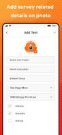
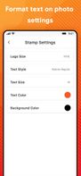
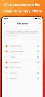
Photos & videos captured here will have easy GPS location stamps, Notes, DateTime stamps & many more. This App can make your survey work as easy as possible.
Who can use this Top survey GPS map camera with Geotagging & timestamp camera App?
? Civil engineers while surveying and leveling construction sites can click photo/video with this app ? Researchers can get highly benefited while sharing field images of land survey to others with exact location details available on the photo map. ? Those Covering accident scenes or disaster management firms may get advantage of this app specially designed for them ?While land surveying, camera timestamp & photo GPS location helps in getting all the details available on the photo before sharing ? On times when real time and location is involved to be shared to others. ?App can help archaeologists to click photo/video with exact location details & Date to time stamps.
Download this App to support your survey work and even while exploring new fields.If you have more suggestion or query write us on:
