
Open Source Travel & Location Apps
Remember traveling before smartphone map apps? Breaking out travel maps, having to stop to reorient yourself on the road, and dreading coming off of a flight just to try and navigate a completely new area? Technology has alleviated this greatly, with apps such as Google Maps aiding in direct navigation and TripAdvisor helping you plan out the most important places to visit.

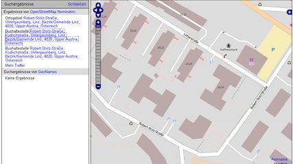
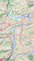
OpenStreetMap is a project aimed squarely at creating and providing free geographic data such as street maps to anyone who wants them. It is a free editable map of the whole world. It is made by people like you.
OpenStreetMap Features
- Crowdsourced
- Turn-by-turn Navigation
- Privacy focused
- Route Planning
- Ad-free
- Voice Navigation
- Geotagging
- Points of Interest (POI)
- Dark Mode
 80 Organic Maps alternatives
- GPS Navigation Service
- Map Service
- Free • Open Source
- Android
- iPhone
- HUAWEI AppGallery
- Flathub
- F-Droid
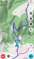
Organic Maps is a privacy-focused and community-developed GPS navigation app for drivers, hikers, and cyclists.
Organic Maps Features
- Works Offline
- No Tracking
- Privacy focused
- Cycling
- Dark Mode
- Turn-by-turn Navigation
- Ad-free
- Route Planning
- Voice Navigation
 105 OsmAnd alternatives
- GPS Navigation Service
- Map Service
- Freemium • Open Source
- Android
- iPhone
- Android Tablet
- iPad
- OpenStreetMap
- F-Droid
- Kindle Fire
OsmAnd is a map and navigation application with access to the free, worldwide, and high-quality OpenStreetMap data.
OsmAnd Features
- Works Offline
- Points of Interest (POI)
- Text to Speech
- Privacy focused
- Turn-by-turn Navigation
- Cycling
- Route Planning
- Hiking Maps
- Ad-free


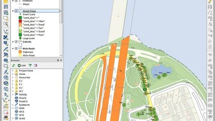
QGIS, formerly Quantum GIS, is a user friendly open source Geographic Information System (GIS) licensed under the GNU General Public License that runs on Linux, Unix, Mac OSX, and Windows and supports numerous vector, raster, and database formats and functionalities.
QGIS Features
- Works Offline
- Route Planning

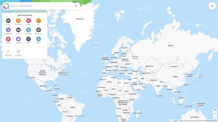
Qwant Map, still in beta, is designed to be an alternative to Google Maps or HERE WeGo, based on OpenStreetMap.
Qwant Maps Features
- Points of Interest (POI)
- No Tracking
- Ad-free

Leaflet is a modern open-source JavaScript library for mobile-friendly interactive maps. It is developed by Vladimir Agafonkin with a team of dedicated contributors. Weighing just about 28 KB of JS code, it has all the features most developers ever need for online maps.
Leaflet Features
 20 GNOME Maps alternatives
- Map Service
- GPS Navigation Service
- Free • Open Source
- Linux
- Linux Mobile
- Flathub
- GNOME
Maps gives you quick access to maps all across the world. We use the collaborative OpenStreetMap database, enabling our users to make smaller changes to places and points-of-interests.
GNOME Maps Features
- Public Transportation
- Ad-free
- Privacy focused
- Dark Mode
- Route Planning

GPS Navigator On-Road/Off-Road for Android and Linux devices.
osmin Features
- Works Offline
- Points of Interest (POI)


Goal of this project is to bring offline maps and navigation to Sailfish OS with native look and feel. OSM Scout for Sailfish OS is based on OSM Scout library.
OSM Scout Features
- Works Offline
- Public Transportation
- Points of Interest (POI)


An Android app which finds wrong, incomplete or extendable data in the user's vicinity and provides the tools to complete these easily and directly on site without having to use another editor.
StreetComplete Features


 36 Marble alternatives
- Map Service
- GPS Navigation Service
- Free • Open Source
- Mac
- Windows
- Linux
- PortableApps.com
Marble is a Virtual Globe and World Atlas that you can use to learn more about Earth: You can pan and zoom around and you can look up places and roads. A mouse click on a place label will provide the respective Wikipedia article.
Marble Features
- Turn-by-turn Navigation
- Portable
- Hiking Maps


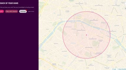
Back Of Your Hand is a map-based game where you're given random street names and you have to locate them on the map. The area can be anywhere in the world (it's not limited to Cork or Ireland). You can play solo or compete with others using multiple phones / computers.

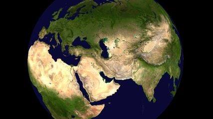
World Wind lets you zoom from satellite altitude into any place on Earth. Leveraging Landsat satellite imagery and Shuttle Radar Topography Mission data, World Wind lets you experience Earth terrain in visually rich 3D, just as if you were really there.
NASA World Wind Features
- Turn-by-turn Navigation
- Works Offline

FacilMap is a privacy-friendly, open-source versatile online map that combines different services based on OpenStreetMap and makes it easy to find places, plan trips and add markers, lines and routes to custom maps with live collaboration.
FacilMap Features
- Route Planning
- Real time collaboration
- Privacy focused
- Points of Interest (POI)
- Ad-free
- Hiking Maps
- Crowdsourced
- No Tracking
- Cycling

Panoramax is a digital resource for sharing and exploiting field photos. Anyone can take photographs of places visible from the public highway and contribute them to the Panoramax database. This data is then freely accessible and reusable by all.
Panoramax Features
- Points of Interest (POI)
- Street View
- Ad-free
- Privacy focused
- No Tracking


